X-Plane 12 officially supported!
Welcome to RealSimGear's G500 Avionics Suite!
Developer: RealSimGear
Download Size: 400MB
Compatibility: Mac & Windows. No Linux.
About the Team
The RealSimGear team is built on experience. The main developer also leads the development of TorqueSim Aircraft Development, known for their SR22s for X-Plane, Islanders, and more! From this experience comes some of the most detailed custom avionics for X-Plane to date - the G500. The RealSimGear G500 is a standalone gauge for X-Plane, meaning it can be added to essentially any aircraft as 2D popups by anyone. It can also be detached into its own window, or used with the RealSimGear G500 hardware (coming soon). For developers, the G500 can be integrated into the 3D cockpit of X-Plane aircraft! See below for more information. The G500 is built on top of RealSimGear’s navigator system, first shown in the RealSimGear Entegra, available in the TorqueSim SR20 and SR22, Entegra Editions. This is just the start for RealSimGear avionics!
Highlighted Features
• Accurate avionics with detailed menus and configurability.
• An integration into default Cessna 172 is included, ready to fly, with the download!
• Already integrated into the TorqueSim BN-2B Islander and BN-2T Turbine Islander - and more integrations are coming!
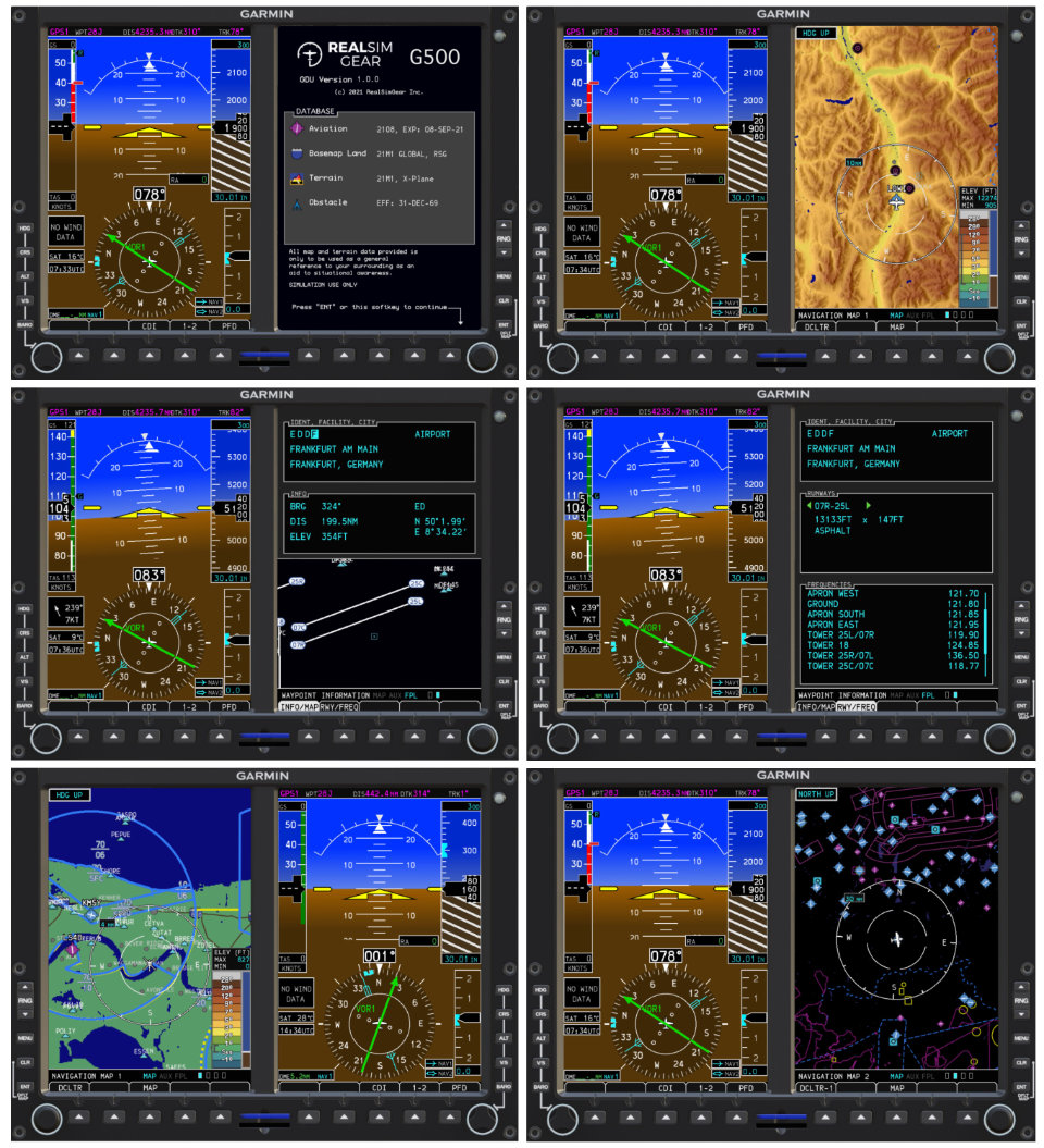
• Detailed map views showing the flight plan, terrain, traffic, airspace, airports, airways, highways, cities, and more! Unparalleled custom avionics for X-Plane.
• Waypoint information page, able to retrieve detailed information about airports, VORs, and more, right from the G500!
• Integration with the RealityXP GTN and GNS avionics for even more accurate behavior!
• Helicopter configuration, with flipped displays for right-sided mounting.
 Detailed Features
• Primary Flight Display (PFD)
• Horizon, airspeed, and altitude information
• Customizable minimums, including radio altimeter integration
• Configurable units (°F/°C, inHg/hPa)
• Detailed CDI, with support for navigation from both NAV1/GPS1 and NAV2/GPS2, and two bearing pointers
• Wind indication, all four display modes available
• Timer and clock
• GPS1 status
• Map View
• Two separately configurable map pages, in addition to TAWS and Traffic pages. These pages are independent of each
other, so you can have different settings on each, making highly configurable setups possible!
• Auto-zoom. This setting, when enabled, will automatically zoom in and out on the map to show the most relevant
information on your flight plan.
• Map detail layers! Many different things are shown on the MFD:
- Terrain and topographic map
- Waterways and oceans
- Airports
- Navigation aids and waypoints
- Airspace boundaries and altitudes
- Highways and cities
- Active flight plan
- Nearby traffic
- Airways
• Configurability
- The various zoom-levels where different data is shown can be configured via the G500 menu. This is configurable on
both MAP1 and MAP2 independently.
- North up and track up modes
• Flight Plan View
• The flight plan page will show what is currently entered, in addition to course, distance, ETA, and cumulative time
estimates for each waypoint.
• The flight plan interfaces with the waypoint information page! Just highlight and select the waypoint of interest, and see
all the relevant information.
• Minimums selector, configure the minimums bar based on the equipped equipment (Baro or Radio minimums).
• Note: The default GNS 530/430 avionics do not expose approach waypoint information. SIDs, STARs, and enroute flight
plans will show up on the G500 map and flight plan page, but approaches will not, due to this Laminar Research
limitation. If this changes, we will integrate full waypoint drawing. This does not affect the HSI for flying approaches, just
the depiction onthe map. RealityXP avionics (GTN 750/650 and GNS 530/430) are fully integrated show waypoints from all
phases of flight without issue.
• Waypoint Information Page
• Airports - Any airport in the X-Plane database can be entered and the key details can be shown
- Bearing and distance from current location
- Elevation and latitude/longitude
- Airport name and city
- A runway diagram of the airport, airspace, and nearby navigational aids and waypoints
- Runway length/width/material information
- Airport frequencies
• Navigational aids and waypoints- Any navigational aid and waypoint can also be entered and can show
- Bearing and distance from current location
- Latitude/longitude and global sector
- Waypoint name and city
- Frequency (if applicable)
- A map of nearby airspace to the navigational aids/waypoint


